Updated at 5:20 p.m.
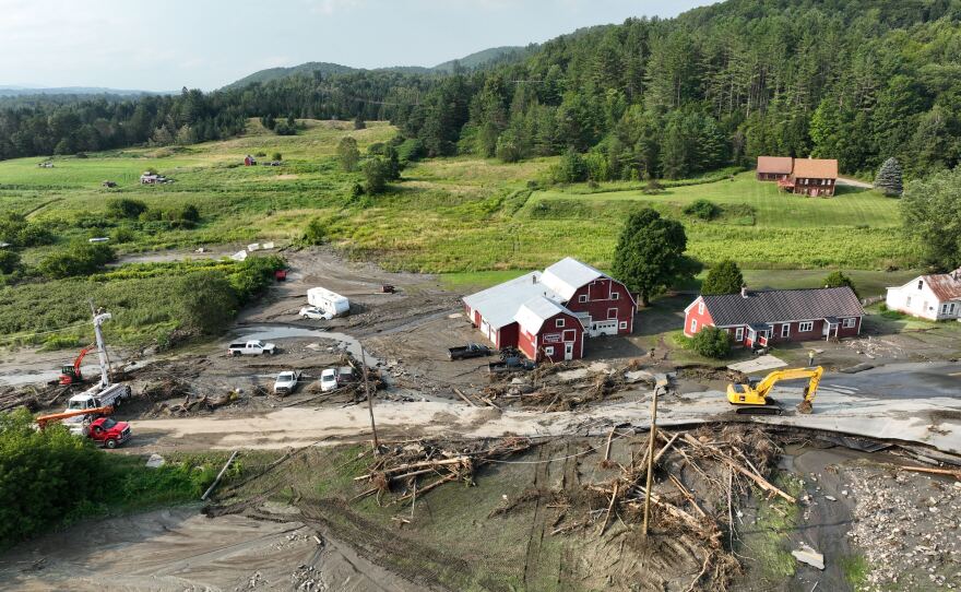
Heavy rainfall caused serious flash flooding in the early morning hours in Vermont's Northeast Kingdom, washing out roads and requiring swift water rescues.
"As long as your house isn't in danger, please stay there," said Vermont Emergency Management Director Eric Forand. If you do have to go out, please do not drive in any standing water — you don't know what will be underneath the surface. And if you do need any help, please call 911 to get that assistance to you as quickly as possible."
Flood warnings remain in effect until 6:45 p.m. for parts of Caledonia and Essex counties.
“The flash flooding overnight was a little more localized than we saw two or three weeks ago — however, it was locally just as severe,” said John Goff, a hydrologist at the National Weather Service in Burlington.
“Reliable rainfall reports of 7 to 8 inches of rain have fallen in downtown St. Johnsbury, also in Morgan, Vermont — that was another hard-hit area," Goff said.
The Fairbanks Museum and Planetarium in St. Johnsbury recorded 7.96 inches of rainfall, the highest single-day total in their 130 years of recorded weather.
Loading...
In East Burke, some people woke up to several inches of water in their yards. And several homes were cut off from the road after driveways and roads washed out.
Town officials including Jim Sullivan, the town administrator, have been out since 5 a.m. assessing damage. By mid-morning, Sullivan was parked next to Mountain Road, watching the floodwaters from Dish Mill Brook.
“We're just going to work our butts off,” he said. “It's what we do. It seems like we do it a lot more often now. But yeah, I'm only laughing because otherwise I'd be crying.”
The storm that hit Burke early this morning was a repeat of flooding earlier this month, when roads were damaged on the west side of town.
“Today this one hit our whole east side,” Sullivan said. “It was just the pummeling — the pummeling that the bridge abutments are taking right now. That's what's causing the damage.”
Parts of East Lyndon were cut off from surrounding roads and inaccessible to emergency workers, as of early afternoon Tuesday.
Between 5 and 8.5 inches of rain fell over parts of the region early this morning and washed out roads connecting Lyndon towards the town of Kirby.
“Every single bridge or culvert that goes to that area is totally gone,” said Jeff Corrow, chief of the Lyndonville Fire Department. “Right now, most of the road is part of the river.”
Several swift water rescue teams have been checking on residents by foot.
“They’ve used ladders to get across some bridges and culverts that are out. I think I heard somebody say they used an excavator to get a ride across,” Corrow said.
So far, rescue teams have reported half a dozen homes that are totally destroyed, and one resident was rescued from flood waters.
“This poor woman had a tiny home built near the river,” Corrow said. “Just as her tiny home got sucked away down the river, she went swimming and my team ended up finding her in the river. She is currently at the hospital, but she’s OK.”
As of 8:45 a.m., Vermont Emergency Management's Forand told Vermont Public that swift water rescues were beginning to wind down, but the teams were on standby as the Passumpsic River continued to rise.

Several road closures are being reported across the Kingdom, including multiple spots of U.S. 2 and U.S. 5 in St. Johnsbury, parts of Route 111 in Morgan and Route 114 in East Burke. For state road closure information, visit newengland511.org or follow @511VT on X. (For local road closures, use the Waze app or monitor town communications, such as a website or Facebook page.)
Flooding has been concentrated over Caledonia and Essex counties in Vermont and northern Grafton County in New Hampshire. Significant flood damage has been reported in East Burke and Lyndonville, according to the National Weather Service.
Warm air, which holds more moisture, is still in place over Vermont. Today, the National Weather Service says additional isolated storms and downpours could result in more flooding and strong winds this afternoon into evening in portions of Caledonia County and the Northeast Kingdom.
On Wednesday, a storm currently over the Great Lakes could bring more heavy downpours and flash flooding to the region.

Flood recovery resources
- For state road closure information, visit newengland511.org or follow @511VT on X. (For local road closures, use the Waze app or monitor town communications, such as a website or Facebook page.)
- You can sign up for alerts from the state at vtalert.gov.
- The latest forecasts and water levels for specific rivers are provided by the National Water Prediction Service.
- Find power outage information at vtoutages.org.
- To find more resources and services, and to report flood damage, call Vermont 2-1-1 or visit vermont211.org.
- For a list of state resources and guidance about flooding, visit vermont.gov/flood. The guidance includes returning home after a flood, cleaning up, and dealing with mold.
- Find flood recovery information in multiple languages at vem.vermont.gov/flood/translation.
- To request cleanup help from volunteers and groups, call the Crisis Cleanup hotline at 802-242-2054.
- For mental health support, call 9-8-8 or call or text the SAMHSA Disaster Distress Helpline at 1-800-985-5990.
- To register through the state to volunteer, visit vermont.gov/volunteer.
- If flood waters reached your private well or spring, order a drinking water test kit through the Vermont Department of Health.
- Find flood-prone areas near you with the Vermont Flood Ready Atlas.
Have questions, comments, or tips? Send us a message.


